

Storm Amy to Hit Britain with Strong Winds and Heavy Rain
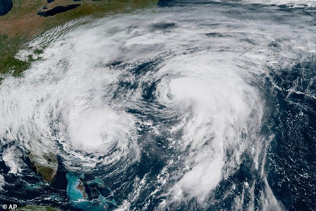
Storm Amy is set to hit Britain, bringing 80mph winds and torrential rain to parts of the country on Friday and Saturday, according to the Met Office. This will be the first named storm of autumn, forming as a separate weather system to the east of Hurricanes Humberto and Imelda, which are also heading across the Atlantic.
Northern and western areas of the UK are expected to be most affected by Storm Amy, with its development influenced by the remnants of Humberto and Imelda. Meteorologists have noted that the hurricanes have accelerated the Atlantic jet stream, contributing to the formation and intensification of Storm Amy in the ocean.
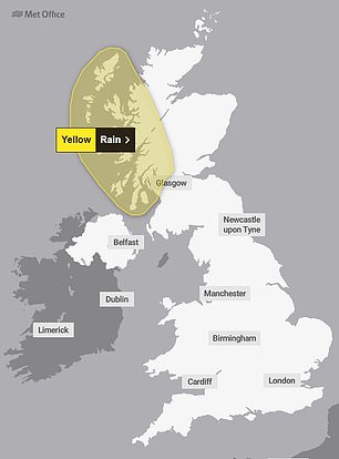
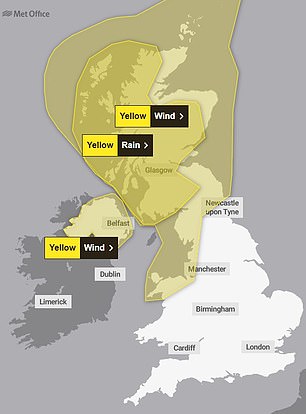
The Met Office has issued several weather warnings for different regions:
- A 31-hour yellow rain warning for western Scotland from 5pm today until the end of tomorrow.
- A 12-hour rain warning for similar areas from Friday midday to midnight.
- A 30-hour yellow wind warning for all of Scotland, North West England, and North Wales from 6pm on Friday until the end of Saturday.
- A 14-hour wind warning for Northern Ireland from 4pm Friday until 6am Saturday.
During the initial rain alert, forecasters warn that areas could be “cut off by flooded roads or landslides,” with flooding causing “difficult driving conditions” and road closures. Power cuts and loss of other services to some homes and businesses are also possible, along with damage to buildings and train cancellations.
When the wind warning begins, the Met Office warns that tiles could be blown from roofs and damage homes. Delays to road, rail, air, and ferry services are likely, along with power cuts and mobile phone coverage outages. There is also a risk of injuries and danger to life from flying debris, and some roads and bridges could close.
Additionally, there is a chance of injuries and danger to life from large waves and beach material being thrown onto sea fronts, coastal roads, and properties.


Storm Names for 2025/26
This year’s storm names, and the countries they come from, are:
- Amy (UK)
- Bram (Ireland)
- Chandra (Netherlands)
- Dave (UK)
- Eddie (Netherlands)
- Fionnuala (Ireland)
- Gerard (Ireland)
- Hannah (Netherlands)
- Isla (UK)
- Janna (Netherlands)
- Kasia (Ireland)
- Lilith (Netherlands)
- Marty (Ireland)
- Nico (Netherlands)
- Oscar (UK)
- Patrick (Ireland)
- Ruby (UK)
- Stevie (UK)
- Tadhg (Ireland)
- Violet (UK)
- Wubbo (Netherlands)
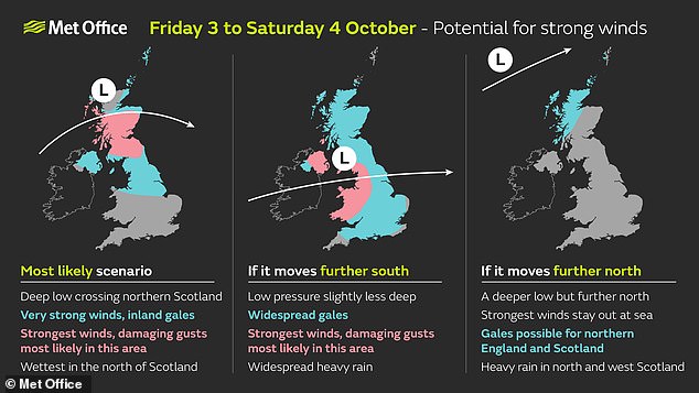
Met Office deputy chief meteorologist Tom Crabtree said there was “still some uncertainty about the exact track Storm Amy will take.” However, he added that the system would bring gale force winds across northern and western regions, with gusts widely reaching 50 to 60mph inland in northern Britain, and potentially reaching 70 to 80mph in places, with even stronger gusts on exposed coasts and hills, mainly in the North West.
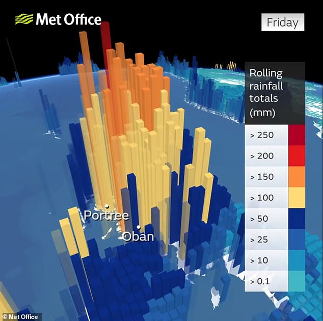
Heavy rainfall is also expected, particularly over western Scotland, where totals could exceed 30 to 50mm in six to nine hours, increasing the risk of localized flooding. The Met Office emphasized the importance of keeping an eye on forecasts for your area over the coming days.
Marco Petagna, senior operational meteorologist at the Met Office, tweeted that there would be a “conveyor belt of rain associated with waving weather fronts.” He added that Storm Amy is expected to undergo rapid cyclogenesis on Friday, also known as a “weather bomb,” when the central pressure of a low-pressure system falls 24 millibars in 24 hours.
Yesterday, Mr. Petagna also said: “Ten inches of rain not out of the question over the highest ground in western Scotland in the next few days… pretty incredible rainfall totals.”
The Met Office expects possible disruption to transport, power supplies, and outdoor activities, especially from Friday evening into Saturday. Martin Thomson from Transport Scotland warned that heavy rain and strong winds could disrupt the transport network in the warning areas, urging drivers to plan their journeys ahead of time.


RAC breakdown spokesman Simon Williams advised that only essential journeys should be made due to the treacherous conditions. He warned of gale-force gusts, surface water, and floods posing risks to life and vehicle damage. The strength of the wind will also lead to dangerous debris on the roads, with staying put until conditions ease being the best advice.
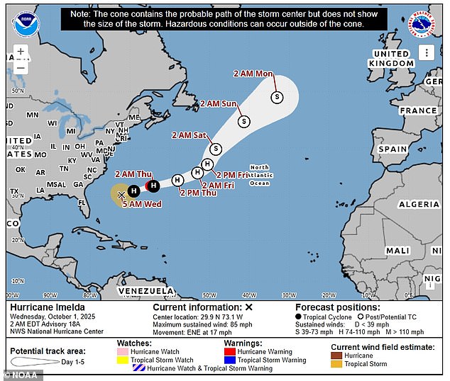
In the Atlantic today, the outer bands of Humberto lashed Bermuda ahead of a more direct pass from the newer and stronger Imelda on the British overseas territory. Imelda, the Atlantic season’s fourth hurricane this year, had maximum sustained winds of 85mph and was expected to strengthen into a Category 2 hurricane.
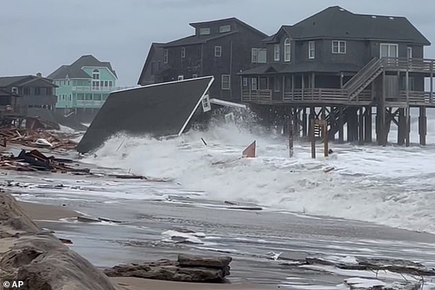
Far northwest of the island, Humberto was still hurricane strength with 80mph winds last night, and the Category 1 storm was moving east-northeast at 10mph. Five unoccupied houses along North Carolina’s Outer Banks collapsed into the ocean yesterday as strong waves rolled in from the Atlantic.
Earlier this week, Imelda battered eastern Cuba, killing two people. Flooding and landslides cut off communities and forced evacuations. One person was also missing in Haiti after Imelda swelled rivers and caused flooding in 35 communities. Imelda also flooded parts of the Bahamas on Monday.

In the UK, Amy is the first in the list of this year’s storm names, compiled by the Met Office with Ireland’s Met Eireann and the Dutch national weather forecasting service KNMI. The Met Office and its partners have been naming storms since 2015, with the list running from early September to the following August to coincide with the start of autumn, when the likelihood of low-pressure systems increases.
In the last year, six storms were named, reaching the letter F with Storm Floris on August 1. Under naming conventions used for storms in the North Atlantic, the list runs alphabetically, missing out Q, U, X, Y, and Z, with names drawn from public submissions in the UK, Ireland, and the Netherlands.
The first name in this year’s list, Amy, was the most popular female name submitted to the Met Office. Storms are given a name when they are deemed to have the potential to cause medium or high impacts in the UK, Ireland, or the Netherlands, with wind the primary focus, although additional issues from rain or snow are also considered.


