
Rising Waters and Widespread Destruction in Northern Vietnam
Four provinces in northern Vietnam are facing severe flooding, with water levels reaching up to 3 meters. Thai Nguyen is expected to remain submerged for the next three days, while Bac Ninh has already exceeded the historical flood levels recorded in 1986.

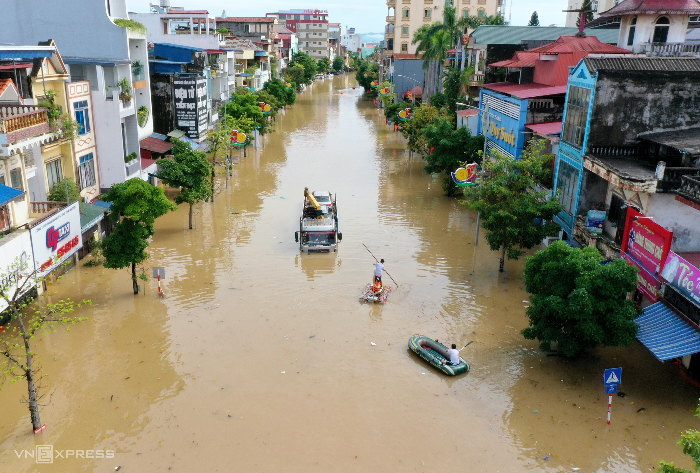
A man rows a makeshift raft on a flooded street in Thai Nguyen Province, Oct. 9, 2025. Photo by VnExpress/Giang Huy
The flooding, caused by Typhoon Matmo, has affected four provinces: Thai Nguyen, Cao Bang, Bac Ninh, and Lang Son. Despite no rain on Wednesday, river levels continued to rise or remain high due to heavy rainfall from previous days. The disaster has led to eight deaths, five missing persons, and seven injuries.
Nearly 17,000 homes have been inundated, including about 5,100 in Thai Nguyen, 7,300 in Cao Bang, and 3,000 in Lang Son. Around 1,600 homes have also been isolated, primarily in Lang Son and Thai Nguyen.
In Thai Nguyen, the Cau River reached a peak of 29.9 meters at the Gia Bay station at 3 a.m. Wednesday, surpassing the historic 2024 flood level by 1.09 meters. The heavy rains have submerged 33 out of 92 communes, with water levels ranging from 1 to 2 meters. In Phan Dinh Phung and Gia Sang communes, floodwaters nearly reached the first floor, forcing residents to take refuge on the second floor. Power outages have caused communication difficulties in some areas, leaving neighborhoods without phone signal and battery power.
The center of Thai Nguyen Province is flooded on the morning of Oct. 8, 2025. Photo by Duy Khac
Le Duy Khac, a resident of central Thai Nguyen, shared that the Cau River overflowed on Tuesday night, rising more than one meter higher by Wednesday morning. “After Typhoon Yagi in 2024, my relatives’ homes in higher areas weren’t flooded, but this year, the water rose over a meter past their houses,” said the 38-year-old. By 7 p.m. Wednesday, the water levels at Gia Bay had receded slightly, but most areas remained deeply submerged. Meteorological agencies have warned that Thai Nguyen will remain flooded for the next two to three days, with the risk of landslides due to waterlogged soil.
In Bac Ninh, located downstream the Cau River, floodwaters have risen rapidly and are expected to peak by Thursday morning. Over the next 12 hours, flood levels at the Cau River are predicted to surpass alarm level 3, the highest, by 1.1 meters. The flood peak on the Thuong River at Cau Son station could rise by 2.45 meters above level three, while at the Phu Lang Son station, it could exceed the record 1986 flood level of 7.52 meters.
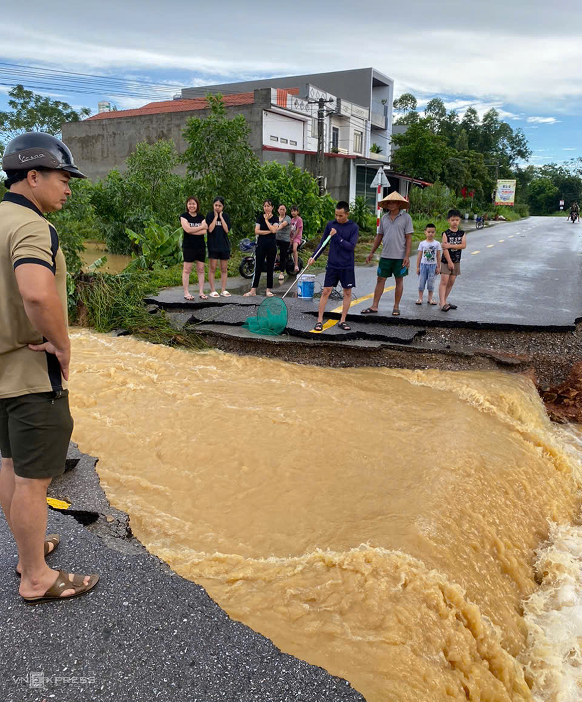
Floodwaters have destroyed a road in Dong Tam Commune of Bac Ninh Province, Oct. 8, 2025. Photo by Than Kien
The mountainous Yen The Commune in Bac Ninh is experiencing its worst flood in years. Than Van Kien, a local shopkeeper, recalled that heavy rains on Tuesday morning caused the floodwaters to rise rapidly, flooding government offices and kindergartens by more than a meter. Many people were unable to return home as roads became impassable. Kien’s shop, located on a slope, had floodwaters almost reaching the stairs. By Wednesday afternoon, the floodwaters had receded from the center of Yen The Commune, but lower-lying areas like Dong Tien and Dong Tam remained submerged up to the roof. While the sun was out, the water receded slowly, and the roads connecting communes were cut off, hampering transportation.
Relief teams are still working to reach flood-isolated communities. “The elders say they’ve experienced the historic 1971 flood, but it wasn’t as severe as this year’s,” Kien said.
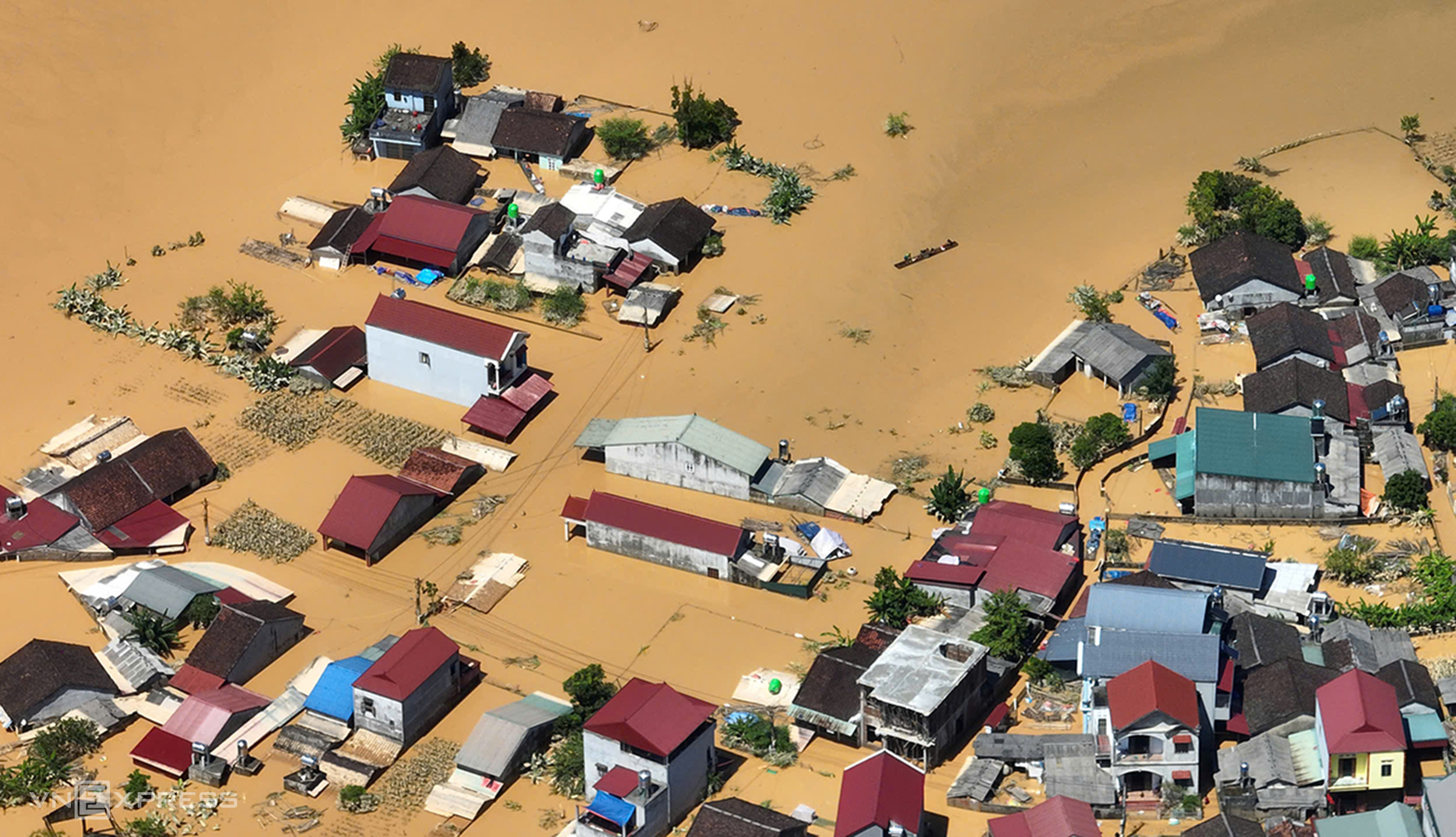
That Khe Commune in Lang Son Province is submerged by floodwaters.. Photo by VnExpress/Ngoc Thanh
The rapid rise in floodwaters has put pressure on the dike system along the Cau and Thuong rivers. Reports from the Bac Ninh Department of Agriculture and Environment indicate that the Thuong River’s right dike in Phuc Hoa Commune has been breached in three places, totaling 850 meters. Authorities are attempting to stop the breaches with sandbags. The right dike of the Cau River has also experienced leaks, and some sections are under surveillance. The dike protecting Ngoai and Dun villages in Tien Luc Commune has been breached, with two sections collapsing over 70 meters, prompting the evacuation of 580 families.
As of 8 p.m. on Wednesday, Bac Ninh reported three deaths, nearly 10,200 people displaced, 50 meters of dike breached, 162 meters of dike eroded, and 1,680 meters of dike requiring reinforcement to prevent further breaches.
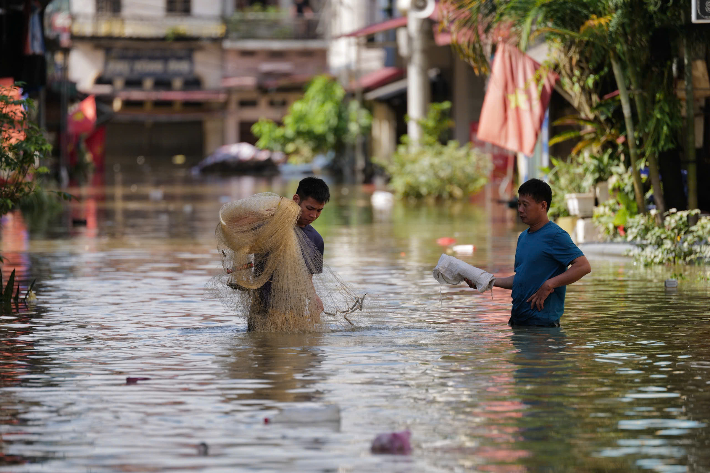
Locals fish on a road that is 3 meters underwater in That Khe Commune, Lang Son Province, on Oct. 8, 2025. Photo by VnExpress/Ngoc Thanh
In Lang Son, two days of rainfall (totaling 180-280 mm) caused the Bac Khe River to experience its worst flood ever, resulting in the breach at Bac Khe 1 hydropower dam, which has a capacity of 4.7 million cubic meters. Over 800 families had been evacuated before the dam failure occurred on Tuesday. About 10 kilometers from the Bac Khe 1 hydropower dam, That Khe Commune is submerged 2-3 meters due to the overflowing dam and continuous heavy rainfall. Many villages are now cut off, and residents’ lives have been severely disrupted.
At 7 p.m. Wednesday, floodwaters on the Trung River in Lang Son reached 24.15 meters, still 1.61 meters above the historic 1986 level. The flooding has affected nearly 2,200 homes, isolated 2,600 homes, caused power outages for 38,200 customers, and disrupted telecommunications. Four helicopters from Regiment 916 of the Air Defense-Air Force took off from Hanoi on Wednesday to deliver nearly nine tons of supplies to the flooded communes of Yen Binh, Van Nham, Huu Lung, and Tuan Son, where thousands of families are surrounded by floodwaters.
In Cao Bang, residents have experienced two rounds of flooding in the past week. Rainfall of 100-200 mm in the past 24 hours caused flooding on the Bang and Hien rivers, submerging homes. Kim Dong Street along the Bang River was submerged over a meter.
Trieu Kim Cuong, a resident of Nuoc Giap Street in Hop Giang Commune, shared that the past week saw two flooding events, on the night of Sept. 30 after Typhoon Bualoi hit and the morning of Oct. 7 after Typhoon Matmo, which were “much worse than the 1986 flood.” The water reached over a meter inside his house, forcing his family to evacuate quickly. By midnight, the floodwaters were still rising rapidly. People stayed awake all night to monitor the floodwaters, which receded slowly by Tuesday afternoon.
The flooding has affected nearly 7,300 homes in the province, submerged over 5,000 hectares of rice and crops, and caused landslides along some national and provincial roads, disrupting transportation.


